Saturday, April 29, 2017

Les voyages d'un Silmaril

Les voyages d'un Silmaril (Atlas du Beleriand - Carte 7)


(cliquez sur l'image pour l'agrandir)


Les voyages d'un Silmaril (Atlas du Beleriand - Carte 7)


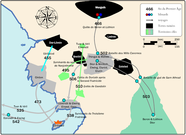
Année après année, à la fin du Premier Âge, les elfes furent poussés sur la côte ouest et ensuite sur l'île de Balar. Cette migration est liée à la progression inexorable des troupes de Morgoth, et à la destinée du Silmaril gagné par Beren et Lúthien poursuivis par l'inaliénable Serment de Fëanor. 

Les dates données proviennent en majorité du texte "The Tale of years"publié dans "The War of The Jewels" [1].

A la fin du Premier age naissent les personnages principaux qui domineront la Terre du Milieu dans l'Âge suivant (le Second Age) : Elrond, Elros and Gil-Galad.


***

A propos de l'Atlas du Beleriand


Cet Atlas est une série de dix cartes (ou plus!) concernant la géographie, l'histoire et la géopolitique dans le Beleriand, le territoire des évènements du Silmarillion.

Cette carte a été créée pour illustrer un essai dédié à la géopolitique en Beleriand publié sur le site JRRvf. La carte a été améliorée et ensuite publiée sur Deviantart.


***

Détails techniques

Deux polices de caractères ont été utilisées : Franklin Gothic Medium et Cardo de David J. Perry.


***

Bibliographie et références

[1] HoMe XI pp342-354


Journey of a Silmaril

Journey of a Silmaril (Atlas of Beleriand - Map 7)


(click to enlarge the picture)


Journey of a Silmaril (Atlas of Beleriand - Map 7)


Year after year, at the end of the First Age, the elfs were pushed up to the west coast and overseas in the island of Balar. This defeat is linked to the unstoppable progress of the troops of Morgoth, and the destiny of the Silmaril regained by Beren and Lúthien followed by the dreadful Oath of Fëanor.

The dates of the First Age given in this map come mostly from the text "The Tale of years" published in "The War of The Jewels" [1].

At the end of the First Age born the valiants seeds of the Second Age : Elrond, Elros and Gil-Galad.


***
About the Atlas of Beleriand

This Atlas is a serie of ten maps (and more !) concerning geography, history and geopolitics of Beleriand, which is a territory of  the famous Legendarium of J.R.R. Tolkien, including the Silmarillion.

This map was firstly created to illustrate an essay (in french) dedicated to explore the geopolitics in Beleriand published on the website JRRVF (many thanks to Cedric for his support).This map was firstly released on Deviantart.


***

Technical details

In these maps, two free fonts are used : Franklin Gothic Medium and Cardo by David J. Perry.


***

Bibliography and references

[1] HoMe XI pp342-354

Saturday, April 22, 2017

Les divisions du Beleriand

Le Beleriand divisé (Atlas du Beleriand - carte 6)


(cliquez sur l'image pour l'agrandir)


Le Beleriand divisé (Atlas du Beleriand - carte 6)


Le Doriath, dirigé par  Elwë Thingol, chef des Sindar, et sa femme Melian la Maia, est un royaume central en Beleriand. La langue du Doriath est le Doriathrin [1], qui est à l'origine de quelques toponymes (Region, Nivrim, etc). Etymologies, un dictionnaire elfique publié dans The Lost Road (HoMe IV), fournit des détails sur la composition des noms [2].

Cette carte montre que la toponymie reflète (pas en totalité, évidemment) cette centralité, avec une structuration est/ouest, proche/lointain, et dedans/dehors, par rapport au Doriath.


Le fleuve Sirion, passant à travers le Doriath, divise naturellement le Beleriand en deux parties, Est et Ouest.  D'un point de vue de la conception du monde secondaire, la structuration est/ouest remonte aux premières esquisses de Tolkien qui possèdent une partie centrale et deux extensions est et ouest [3]. La partie centrale inclut Menegroth, Nargothrond et Gondolin, ce qui signifie que ces trois cités constituent l'Omphalos du Legendarium de Tolkien [4].


***

A propos de l'Atlas du Beleriand


Cet Atlas est une série de dix cartes (ou plus!) concernant la géographie, l'histoire et la géopolitique dans le Beleriand, le territoire des évènements du Silmarillion.

Cette carte a été créée pour illustrer un essai dédié à la géopolitique en Beleriand publié sur le site JRRvf. La carte a été améliorée et ensuite publiée sur Deviantart.

***

Détails techniques

Deux polices de caractères ont été utilisées : Franklin Gothic Medium et Cardo de David J. Perry.

***

Bibliographie et références

[1] See Ardalambion website, section "Doriathrin - the Mothertongue of Lúthien" :
[2] HoMe IV pp347-400
[3] HoMe III p219
[4] The three Great Tales concerns Beren & Lúthien, the children of Húrin, and the fall of Gondolin (see HoMe X p373).


The Divisions of Beleriand

The Divisions of Beleriand (Atlas of Beleriand - Map 6)


(click to enlarge the picture)


The Divisions of Beleriand (Atlas of Beleriand - Map 6)


The Doriath, ruled by Elwë Thingol, chief of Sindar, and his wife Melian the Maia, is a powerful and central kingdom in Beleriand. The tongue of Doriath was Doriathrin [1], which provided several toponyms in Beleriand.  Etymologies, an elfic dictionary published in The Lost Road (HoMe IV), provide some details on the composition of names [2].

The river Sirion, passing through Doriath, naturally divided Beleriand in two parts : East and West Beleriand. On an external point of view, the structuration east/west roots on the former maps drawn by Tolkien, with one central part (including Menegroth) and two extensions east/west [3]. The central map includes Menegroth, Nargothrond and Gondolin which means this is the geographical core of the Tolkien's Great Tales and Legendarium [4].


***

About the Atlas of Beleriand

This Atlas is a serie of ten maps (and more !) concerning geography, history and geopolitics of Beleriand, which is a territory of  the famous Legendarium of J.R.R. Tolkien, including the Silmarillion.

This map was firstly created to illustrate an essay (in french) dedicated to explore the geopolitics in Beleriand published on the website JRRVF (many thanks to Cedric for his support).This map was firstly released on Deviantart.


***

Technical details

In these maps, two free fonts are used : Franklin Gothic Medium and Cardo by David J. Perry.


***

Bibliography and references

[1] See Ardalambion website, section "Doriathrin - the Mothertongue of Lúthien" :
[2] HoMe IV pp347-400
[3] HoMe III p219
[4] The three Great Tales concerns Beren & Lúthien, the children of Húrin, and the fall of Gondolin (see HoMe X p373).

Saturday, April 15, 2017

La Plaine Fortifiée

La Plaine Fortifiée (Atlas du Beleriand - Carte 5)


(cliquez sur l'image pour l'agrandir)


La Plaine Fortifiée (Atlas du Beleriand - Carte 5)


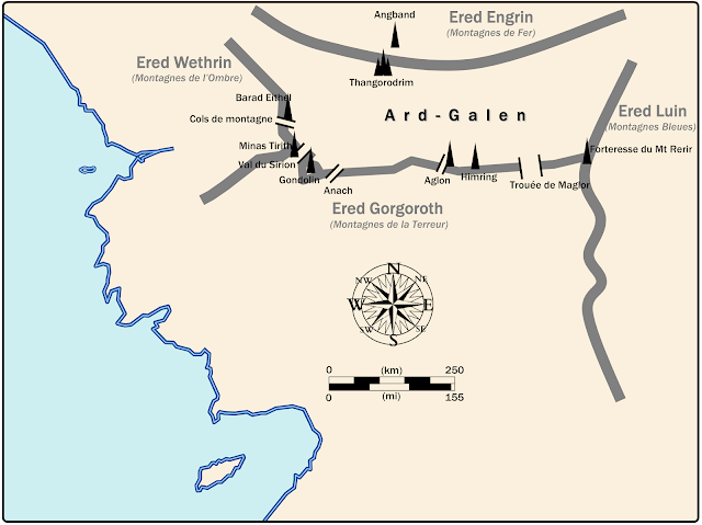
Durant le Siège d'Angband, Morgoth fut encerclé par les Elfes Ñoldor autour de la Plaine d'Ard-Galen.

L'encerclement de Morgoth et son retranchement dans Angband sont aidés par l'orographie. La plaine est encadrée par les montagnes, et elles sont percées par des cols et gardées par des forteresses [1]. La plaine était gardée par des hmmes do'armes et des espions : cavaliers elfes dans les basses terres, et aigles majestueux dans les Crissaegrim (entre Anach et le Val du Sirion) [2].

Les montagnes au sud de la plaine constituaient une barrière naturelle à l'extension de Morgoth. Bien qu'il fut retranché dans Angband, il eut un renfort infini dans ces caves souterraines.

En face de lui, l'alliance elfe était fragile à cause de tensions internes. De plus, les elfes hésitaient à se lancer dans une guerre à l'issue incertaine [3]. Cependant, durant quatre siècles, cette alliance fut suffisante pour arrêter les orques aux portes du Beleriand. La situation changea dramatiquement avec l'attaque soudaine de Morgoth appelée Dagor Bragollach, prélude à la défaite pour les elfes. Lors de cette attaque, Ard-Galen la verte plaine fut brûlée et devient une plaine de cendres, elle fut alors appelée Anfauglith.

L'expression "la Plaine Guardée" écrit bien Ard-Galen, mais elle s'applique à Talath Dirnen, la plaine entre Nargothrond et le Doriath dans le Beleriand Ouest.


***

A propos de l'Atlas du Beleriand


Cet Atlas est une série de dix cartes (ou plus!) concernant la géographie, l'histoire et la géopolitique dans le Beleriand, le territoire des évènements du Silmarillion.

Cette carte a été créée pour illustrer un essai dédié à la géopolitique en Beleriand publié sur le site JRRvf. La carte a été améliorée et ensuite publiée sur Deviantart.


***

Détails techniques

Deux polices de caractères ont été utilisées : Franklin Gothic Medium et Cardo de David J. Perry.


***

Bibliographie et références

[1] La forteresse de Tol Sirion fut dessinée par Tolkien. Voir le livre "Pictures of JRR Tolkien" dessin n°36.
[2] Silmarillion, p102
"For Manwë to whom all birds are dear, and to whom they bring news upon Taniquetil from Middle-earth, had sent forth the race of Eagles, commanding them to dwell in the crags of the North, and to keep watch upon Morgoth;" 
[3] Silmarillion, p138
"But because the land was fair and their kingdoms wide, most of the Noldor were content with things as they were, trusting them to last, and slow to begin an assault in which many must surely perish were it in victory or in defeat Therefore they were little disposed to hearken to Fingolfin, and the sons of Fëanor at that time least of all."

The Fortified Plain


The Fortified Plain (Atlas of Beleriand - Map 5)

(click to enlarge the picture)


The Fortified Plain (Atlas of Beleriand - Map 5)


During the Siege of Angband (F.A. 7-455), Morgoth was surrounded by the Ñoldor around the plain of Ard-Galen. The Black Enemy was entrenched in the citadel of Angband.

The plain was framed by the mountains, which are pierced with many passes and kept by strongholds [1]. The plain were guarded by many guards and spies : elvish horse riders in the lowland plains, and majestic eagles nestled in the Crissaegrim [2].

Morgoth was surrounded by the Ñoldor, and the southern mountains was a natural barrier to his extension. Although he was entrenched in his fortress of Angband, he get an indefinite supply produced by slaves in deep underground caves.

In front of him, the elf alliance was fragile due to many frictions between the allied forces. In addition, elfs hesitated to start an unsure war [3].  However, during four centuries, this alliance was sufficient to stop the orks at the gates of Beleriand.  The situation changed dramatically with the sudden attack of Morgoth and the beginning of the Dagor Bragollach, the prelude to the defeat for the elfs.  At this time, Ard-Galen the green plain was burned to become an ash plain, and was called  Anfauglith.

The words "Guarded Plain" describe well Ard-Galen, but they actually apply to Talath Dirnen, the desert plain between Nargothrond and Doriath in West Beleriand.

***

About the Atlas of Beleriand


This Atlas is a serie of ten maps (and more !) concerning geography, history and geopolitics of Beleriand, which is a territory of  the famous Legendarium of J.R.R. Tolkien, including the Silmarillion.

This map was firstly created to illustrate an essay (in french) dedicated to explore the geopolitics in Beleriand published on the website JRRVF (many thanks to Cedric for his support).This map was firstly released on Deviantart.


***

Technical details

In these maps, two free fonts are used : Franklin Gothic Medium and Cardo by David J. Perry.


***

Bibliography and references

[1] The fortress of Tol Sirion was drawn by Tolkien, see the book "Pictures of JRR Tolkien" number 36.
[2] Silmarillion p102
"For Manwë to whom all birds are dear, and to whom they bring news upon Taniquetil from Middle-earth, had sent forth the race of Eagles, commanding them to dwell in the crags of the North, and to keep watch upon Morgoth;" 
[3] Silmarillion p138
"But because the land was fair and their kingdoms wide, most of the Noldor were content with things as they were, trusting them to last, and slow to begin an assault in which many must surely perish were it in victory or in defeat Therefore they were little disposed to hearken to Fingolfin, and the sons of Fëanor at that time least of all." 

Saturday, April 8, 2017

The lands of Men

The lands of Men (Atlas of Beleriand - Map 4)


(click to enlarge the picture)

The lands of Men (Atlas of Beleriand - Map 4)


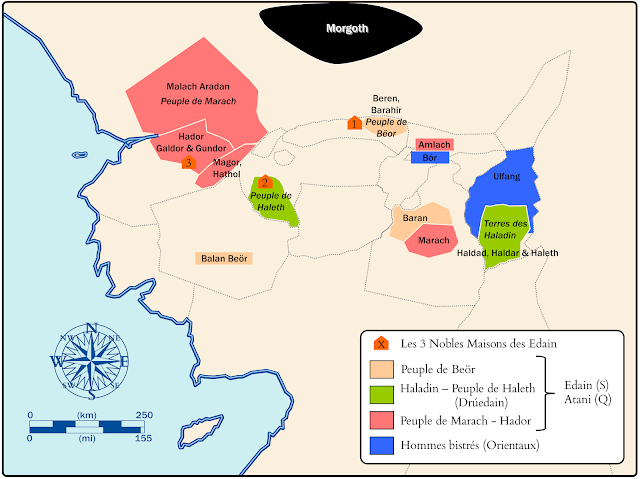
This map shows the settlements of the Men in Beleriand. Men awoke in far East, in Hildórien, when the Sun appeared above Middle-Earth [1]. Three centuries later, men arrived in East Beleriand and they were discovered by the Ñoldor elf Finrod in the Blue Mountains.

The heroes of men (Húrin, Túrin, Beren, etc) come from the Three Houses of the Edain, the noblest men in Beleriand.

The settlement of men in Estolad (leaded by Baran and Marach) involved frictions with the Nandor elfs of Ossiriand and Arthórien [2]. On the Tolkien's map, no river or water appears in Estolad ; however this is a green and fertile country [3].

At the end of the First Age, the Beleriand was drowned, and the Edain was invited to live in the great island of Númenor.


***

About the Atlas of Beleriand


This Atlas is a serie of ten maps (and more !) concerning geography, history and geopolitics of Beleriand, which is a territory of  the famous Legendarium of J.R.R. Tolkien, including the Silmarillion.

This map was firstly created to illustrate an essay (in french) dedicated to explore the geopolitics in Beleriand published on the website JRRVF (many thanks to Cedric for his support).This map was firstly released on Deviantart.


***

Technical details

In these maps, two free fonts are used : Franklin Gothic Medium and Cardo by David J. Perry.


***

Bibliography and references

[1] HoMe IV p249
[2] HoMe XI p112
[3] Silmarillion XVII p131
"But Marach, hearing that the people of Bëor were dwelling in a green and fertile land, came down the Dwarf-road, and settled in the country south ; and east of the dwellings of Baran son of Bëor; and there was great friendship between those peoples." 

Les terres des Hommes

Les terres des Hommes (Atlas du Beleriand - Carte 4)


(cliquez sur l'image pour l'agrandir)

Les terres des Hommes (Atlas du Beleriand - Carte 4


Cette carte montre les territoires des Hommes en Beleriand. Les Hommes s'éveillèrent dans l'Est lointain, en Hildórien, quand le Soleil apparut au-dessus de la Terre du Milieu [1]. Trois siècles plus tard, ils arrivèrent en Beleriand Est où ils furent découverts par l'elfe Finrod des Ñoldo, dans les Montagnes Bleues. Ils se répartirent ensuite dans le Beleriand ; cette carte résume les migrations complexes racontées dans le chapitre 17 du Silmarillion.

 Les principales figures héroïques (Húrin, Túrin, Beren, etc) viennent des Trois Maison des Edain, les plus nobles hommes de Beleriand.

L'établissment des Hommes en Estolad (dirigés par Baran et Marach) créérent des frictions avec les elfes Nandor installés en Ossiriand et Arthórien [2]. Sur la carte de Tolkien, aucune rivière n'apparaît ; on sait cependant que cette contrée était verte et fertile [3].

A la fin du Premier Âge, le Beleriand fut submergé, et les Edain furent invités dans la grande île de Númenor.


***

A propos de l'Atlas du Beleriand

Cet Atlas est une série de dix cartes (ou plus!) concernant la géographie, l'histoire et la géopolitique dans le Beleriand, le territoire des évènements du Silmarillion.

Cette carte a été créée pour illustrer un essai dédié à la géopolitique en Beleriand publié sur le site JRRvf. La carte a été améliorée et ensuite publiée sur Deviantart.


***

Détails techniques

Deux polices de caractères ont été utilisées : Franklin Gothic Medium et Cardo de David J. Perry.


***

Bibliographie et références

[1] HoMe IV p249
[2] HoMe XI p112
[3] Silmarillion XVII p131
"But Marach, hearing that the people of Bëor were dwelling in a green and fertile land, came down the Dwarf-road, and settled in the country south ; and east of the dwellings of Baran son of Bëor; and there was great friendship between those peoples." 
 

Saturday, April 1, 2017

Kingdoms of the Ñoldor

Kingdoms of the Ñoldor (Atlas of Beleriand - Map 3)


(click on the picture to enlarge it)

Kingdoms of the Ñoldor (Atlas of Beleriand - Map 3)


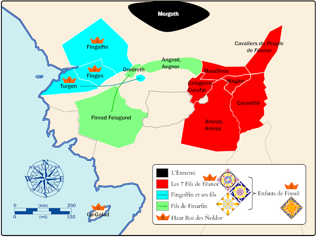
This map shows the settlements of the Ñoldor in Beleriand. All the Ñoldor are gathered by the desire to revenge the death of their ancestor Finwë, killed by Morgoth and Ungoliantë [1].

Although the colors seem well distributed, the positions of elfs are not equivalent. The sons of Finarfin occupy the most dangerous territories, probably because their father Finarfin go back to Valinor. Angrod and Aegnor settled in the northern slopes of Dorthonion [2], at a stone's throw from the hosts of Morgoth. Galadriel was the daugther of Finarfin, but she did not ruled a land although she went often to Doriath as a guest. The territories of Fingolfin are depicted in blue because his banner was blue and silver.

In this map, the territory of Maglor is extended far in the north and east because the Ñoldor encircle literally the Enemy entrenched in Angband [3]. Although there is no town or fortress, the riders of Fëanor dwell in this region [4].

The orange crown indicates the succession order for the title of High King of the Ñoldor.


***

About the Atlas of Beleriand


This Atlas is a serie of ten maps (and more !) concerning geography, history and geopolitics of Beleriand, which is a territory of  the famous Legendarium of J.R.R. Tolkien, including the Silmarillion.

This map was firstly created to illustrate an essay (in french) dedicated to explore the geopolitics in Beleriand published on the website JRRVF (many thanks to Cedric for his support).This map was firstly released on Deviantart.


***

Technical details

In these maps, two free fonts are used : Franklin Gothic Medium and Cardo by David J. Perry.


***

Bibliography and references

[1] HoMe X, pp 248, 294, 298
[2] HoMe XI, p 38
"but Angrod and Egnor held the north slopes of Dorthonion as far as Aglon where began the March of Maidros aforesaid." 
[3] Silmarillion §13 Of the Return of the Noldor
"But the Noldor being again united set a watch upon the borders of Dor Daedeloth, and Angband was beleaguered from west, and south, and east" 
[4] Silmarillion §14 Of Beleriand and Its Realms
"In that region, upon the March of Maedhros and in the lands behind, dwelt the sons of Fëanor with many people; and their riders passed often over the vast northern plain, Lothlann the wide and empty, east of Ard-galen, lest Morgoth should attempt any sortie towards East Beleriand." 


Les royaumes des Elfes Ñoldor

Les royaumes des Elfes Ñoldor (Atlas of Beleriand - Map 3)


(cliquez sur l'image pour l'agrandir)

Les royaumes des Elfes Ñoldor (Atlas of Beleriand - Map 3)


Cette carte montre l'implantation géographique des Ñoldor en Terre du Milieu. Les Ñoldor vinrent en Terre du Milieu pour venger la mort de leur ancêtre Finwë, tué par Morgoth et Ungoliantë [1].


Les couleurs semblent distribuées de manière équitable, cependant les positions n'étaient pas équivalentes. Les fils de Finarfin occupaint les territoires les plus exposés à l'Ennemi. Probablement parceque leur père Finarfin était retourné en Valinor. Angrod et Aegnor résidaient en Dorthonion, à un jet de pierre de Morgoth. Galadriel était la fille de Finarfin, mais elle ne régna sur aucun territoire, elle vint souvent en Doriath en tant qu'invité. Les territoires de Fingolfin et de ses fils sont en bleu car sa bannière était bleu et argent. 

On constate que le territoire de Maglor est étendu loin dans le Nord parceque les Ñoldor encerclaient l'Ennemi retranché dans Angband [3]. Bien qu'il n'y ait pas de cité ou de forteresse, les cavaliers de Fëanor résidaient dans ces plaines [4].

La couronne indique l'ordre de succession au titre de Haut Roi des Ñoldor


***

A propos de l'Atlas du Beleriand

Cet Atlas est une série de dix cartes (ou plus!) concernant la géographie, l'histoire et la géopolitique dans le Beleriand, le territoire des évènements du Silmarillion.

Cette carte a été créée pour illustrer un essai dédié à la géopolitique en Beleriand publié sur le site JRRvf. La carte a été améliorée et ensuite publiée sur Deviantart.


***

Détails techniques

Deux polices de caractères ont été utilisées : Franklin Gothic Medium et Cardo de David J. Perry.


***

Bibliographie et références

[1] HoMe X, pp 248, 294, 298
[2] HoMe XI, p 38
"but Angrod and Egnor held the north slopes of Dorthonion as far as Aglon where began the March of Maidros aforesaid." 
[3] Silmarillion §13 Of the Return of the Noldor
"But the Noldor being again united set a watch upon the borders of Dor Daedeloth, and Angband was beleaguered from west, and south, and east" 
[4] Silmarillion §14 Of Beleriand and Its Realms
"In that region, upon the March of Maedhros and in the lands behind, dwelt the sons of Fëanor with many people; and their riders passed often over the vast northern plain, Lothlann the wide and empty, east of Ard-galen, lest Morgoth should attempt any sortie towards East Beleriand."