Saturday, May 20, 2017

Safari ou croisière ?

Voyages en Beleriand (Atlas du Beleriand - Carte 10)


(cliquez sur l'image pour l'agrandir)


Voyages en Beleriand (Atlas du Beleriand - Carte 10)


Le Beleriand était divisé en deux grandes parties Est/Ouest par une barrière géographique consistant en régions périlleuses, sauvages ou gardées. Cette barrière, symbolisée dans cette carte par la couleur rouge, s'étendait de Dor Daedeloth au nord jusqu'à Taur-Im-Duinath au sud.

Peu de chemins traversaient cette "barrière centrale". Ces chemins constituaient les grandes routes à travers le Beleriand. Ils furent utilisés par les Nains pour le commerce, les Hommes durant leurs migrations, et quelques elfes courageux, comme Galadriel ou Finrod. Celuci-ci était connu pour voyager beaucoup.


La première série de 10 cartes est maintenant complète !


***

A propos de l'Atlas du Beleriand

Cet Atlas est une série de dix cartes (ou plus!) concernant la géographie, l'histoire et la géopolitique dans le Beleriand, le territoire des évènements du Silmarillion.

Cette carte a été créée pour illustrer un essai dédié à la géopolitique en Beleriand publié sur le site JRRvf. La carte a été améliorée et ensuite publiée sur Deviantart.


***

Détails techniques

Deux polices de caractères ont été utilisées : Franklin Gothic Medium et Cardo de David J. Perry.


***

Bibliographie et référence

  •  K. W. Fonstad, The Atlas of Middle-Earth, revised edition, Houghton Mifflin, 1991

Saturday, May 13, 2017

La tragique fin du Beleriand

La fin du Beleriand (Atlas du Beleriand - carte 9)


(cliquez sur l'image pour l'agrandir)


La fin du Beleriand (Atlas du Beleriand - carte 9)


Après la Guerre de la Grande Colère, la dernière bataille du Premier Âge,le Beleriand fut brisé et englouti par la Grande Mer, Belegaer. Quelques îles et rochers subsistèrent au large de la Terre du Milieu, Tol Morwen par exemple [1]. Une partie du Beleriand devint le Lindon.

Cette carte fait la jonction entre la carte du Seigneur des Anneaux et celle du Silmarillion. Le problème posé par la jonction fut discuté par Charles Noad [2], Ronald E. Kyrmse [3] et Didier Willis [4]. La tentative de Karen W. Fonstad dans son Atlas de la Terre du Milieu [5] pose problème. 


***

A propos de l'Atlas du Beleriand


Cet Atlas est une série de dix cartes (ou plus!) concernant la géographie, l'histoire et la géopolitique dans le Beleriand, le territoire des évènements du Silmarillion.

Cette carte a été créée pour illustrer un essai dédié à la géopolitique en Beleriand publié sur le site JRRvf. La carte a été améliorée et ensuite publiée sur Deviantart.

***

Détails techniques

Deux polices de caractères ont été utilisées : Franklin Gothic Medium et Cardo de David J. Perry.

***


Bibliographie et références

[1] HOME XI p.296.
"As after indeed befell, and still the Tol Morwen stands alone in the water beyond the new coasts that were made in the days of the wrath of the Valar." 
See the awesome depiction of Tol Morwen published on DeviantART by digital-fantasy :www.deviantart.com/art/tol-mor…
[2] "A Note on the Geography of the First Age" in Amon Hen 38, april 1979.
[3] "The Geographical Relation between Beleriand and Eriador" in Mallorn 26, pp 25-26, september 1989.
[4] "Du Beleriand aux confins de Rhûn - Collages et reconstructions cartographiques" in the anthology Tolkien, le façonnement d'un monde 2014, pp 197-230.
[5] K. W. Fonstad, The Atlas of Middle-Earth, revised edition, Houghton Mifflin, 1991.


Beleriand at the End of the First Age

Beleriand at the End of the First Age (Atlas of Beleriand - Map 9)


(click to enlarge the picture)

Beleriand at the End of the First Age (Atlas of Beleriand - Map 9)

After the War of Wrath, the last great battle in the First Age, the Beleriand was broken and swallowed by the Great Sea, Belegaer. Only few islands and rocks subsisted (such as Tol Morwen [1]), whereas a part of East Beleriand become the Lindon.

This map shows the junction between the map of the Lord of the Rings and the map of the Silmarillion. The problem of the junction was discussed previously by Charles Noad [2], Ronald E. Kyrmse [3] and Didier Willis [4]. The attempt of Karen W. Fonstad in her Atlas of Middle-Earth [5] was clearly unsuccessful.

***

About the Atlas of Beleriand

This Atlas is a serie of ten maps (and more !) concerning geography, history and geopolitics of Beleriand, which is a territory of  the famous Legendarium of J.R.R. Tolkien, including the Silmarillion.

This map was firstly created to illustrate an essay (in french) dedicated to explore the geopolitics in Beleriand published on the website JRRVF (many thanks to Cedric for his support).This map was firstly released on Deviantart.

***

Technical details
In these maps, two free fonts are used : Franklin Gothic Medium and Cardo by David J. Perry.

***


Bibliography and references
[1] HOME XI p.296.
"As after indeed befell, and still the Tol Morwen stands alone in the water beyond the new coasts that were made in the days of the wrath of the Valar." 
See the awesome depiction of Tol Morwen published on DeviantART by digital-fantasy :www.deviantart.com/art/tol-mor…
[2] "A Note on the Geography of the First Age" in Amon Hen 38, april 1979.
[3] "The Geographical Relation between Beleriand and Eriador" in Mallorn 26, pp 25-26, september 1989.
[4] "Du Beleriand aux confins de Rhûn - Collags et reconstructions cartographiques" in the anthology Tolkien, le façonnement d'un monde 2014, pp 197-230.
[5] K. W. Fonstad, The Atlas of Middle-Earth, revised edition, Houghton Mifflin, 1991

Saturday, May 6, 2017

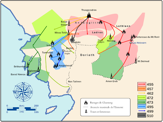
Les conquêtes de l'Ennemi

Les conquêtes de l'Ennemi (Atlas du Beleriand - Carte 8)


(cliquez sur l'image pour l'agrandir)

 Les conquêtes de l'Ennemi (Atlas du Beleriand - Carte 8)


Durant le Premier Âge, la puisssance de Morgoth augmenta de manière continue. Les caves les plus profondes d'Angband étaient remplies d'armes, d'esclaves et de soldats.  Morgoth n'appliqua qu'une seule stratégie : la conquête brutale. N'étant pas lui-même sur les champs de bataille, des Balrogs menaient les troupes. De ce point de vue, Sauron se révéla bien plus rusé que son maître.

Du point de vue de l'Ennemi, la division Est/Ouest du Beleriand est une difficulté car il doit diviser ses troupes. Le corridor Est (la passe de Maglor) était défendu par les fils de Fëanor, tandis que le corridor ouest (le Val du Sirion et la forteresse de Minas Titith - homonyme de celle du Seigneur des Anneaux) était défendu par les fils de Finarfin.

Le dragon Glaurung fut une pièce maîtresse dans l'avancée de Morgoth, puisque le dragon gagna toutes les batailles (excepté lors de sa première sortie en 260). Il bris les défenses à l'Est en 455, et enfonca l'Ouest cinquante ans plus tard. Glaurung seul aurait pu conquérir le Beleriand, mais il possédait sa volonté propre [1] et son destin rencontra celui de Túrin Turambar.

Morgoth ne put jamais conquérir tout le Beleriand : Ulmo protégeait Nan Tathren et le Sirion, et la forteresse d'Amon Ereb resta à l'Est.

Doriath fut régulièrement attaqué sur deux fronts mais il était protégé par l'Anneau de Melian. Quand Thingol fut assassiné par les Nains, Melian la Maia quitta Doriath et l'Anneau fut dissous.  Le royaume fut détruit par les fils de Fëanor et par son serment, non par les orques.


***

A propos de l'Atlas du Beleriand


Cet Atlas est une série de dix cartes (ou plus!) concernant la géographie, l'histoire et la géopolitique dans le Beleriand, le territoire des évènements du Silmarillion.

Cette carte a été créée pour illustrer un essai dédié à la géopolitique en Beleriand publié sur le site JRRvf. La carte a été améliorée et ensuite publiée sur Deviantart.

***

Détails techniques

Deux polices de caractères ont été utilisées : Franklin Gothic Medium et Cardo de David J. Perry.

***


Bibliographie et références

[1] HoMe V p254


Conquests of the Enemy

Conquests of the Enemy (Atlas of Beleriand - Map 8)


(click to enlarge the picture)

 Conquests of the Enemy (Atlas of Beleriand - Map 8)


During the First Age, the powerful of Morgoth increased continuously. The deepest caves of Angband were full of treacherous weapons, slaves and soldiers. Morgoth applied one strategy, brutal conquest, for one result, domination. His power was embodied in Balrogs which commanded his troops.

On the enemy point of view, the division west/east of Beleriand is a major difficulty , due to the existence of two corridors between Ard-Galen and the inland. The east corridor (the Maglor's gap) was defended by the sons of Fëanor, and the west corridor (the Sirion's Vale) by sons of Finarfin. Morgoth may be divide his troops in two  groups.

The dragon Glaurung was the major asset of Morgoth, because he won all his battles (except his first  early release in 260). He breached the East in 455, and the West fifty years later. Glaurung alone could have conquier all the Beleriand, however he possessed his own will [1] and was killed by Túrin.

Finally Morgoth did not conquier all the Beleriand : Ulmo protected Nan Tathren and the Sirion, and the stronghold of Amon Ereb stands in the East.

Doriath was regularly attacked on two frontlines but was protected by the Girdle of Melian. When Thingol was killed, Melian left Doriath and the Girdle was dissolved. Then the kingdom was destroyed by the sons of Fëanor and his irrevocable oath, nor by the orks.


***

About the Atlas of Beleriand

This Atlas is a serie of ten maps (and more !) concerning geography, history and geopolitics of Beleriand, which is a territory of  the famous Legendarium of J.R.R. Tolkien, including the Silmarillion.

This map was firstly created to illustrate an essay (in french) dedicated to explore the geopolitics in Beleriand published on the website JRRVF (many thanks to Cedric for his support).This map was firstly released on Deviantart.


***

Technical details

In these maps, two free fonts are used : Franklin Gothic Medium and Cardo by David J. Perry.


***

Bibliography and references

[1] HoMe V p254