Saturday, March 25, 2017

Cinquante nuances d'Elfes Gris

(cliquez sur l'image pour l'agrandir)


Les Elfes Gris du Beleriand (Atlas du Beleriand - Carte 2)


Cette carte montre les royaumes des elfes Teleri, qui étaient divisés principalement en deux groupes : Sindar et Laiquendi. Le mot elfique Sindar désigne la couleur grise, tandis que Laiquendi signifie "Elfes Verts". Leurs territoires figurent sur la carte en gris et vert, respectivement.

Les Sindar étaient en Beleriand bien avant l'arrivée des Ñoldor, et Elwë Thingol était considéré comme leur régent. Quelques Sindar étaient installés en Mithrim [1], et d'autres en Nevrast [2].  Ceux-ci furent un peu bousculés par l'arrivée des Ñoldor, et ceux de Nevrast suivirent Turgon en Gondolin ; le Nevrast resta vide.

En position centrale se trouve le Doriath, entouré par l'Anneau de Melian, qui subsista jusqu'au départ de celle-ci à la mort de son époux Thingol. Ce royaume forestier, aussi vaste que toute la Bretagne, était divisé en plusieurs parties : Brethil, Region, Neldoreth, Nivrim, Arthórien et Brethil [4]. Après la Première Bataille, quelques Nandor s'installèrent en Arthórien [5], dont Ithilbor, le père du fameux Saeros qui fut tué par Túrin Turambar. 

A l'est de Doriath, dans la ténébreuse forêt de Nan Elmoth,  vivait Eöl ; cet elfe est souvent désigné comme Elfe Noir, mais cela n'a rien à voir avec les Elfes Noirs de la fantasy. Eöl mourut tragiquement en Gondolin en l'an 400 du Premier Âge ; il est probable que la forêt de Nan Elmoth fut ensuite rattachée au Doriath.

Les Falathrim, qui résidaient sur la côte Est du Beleriand, étaient dirigés par Círdan, elfe bien connu des lecteurs du Seigneur des Anneaux ; c'est lui qui possédait Narya, l'un des trois anneaux elfes. Celui-ci était aussi appelé Nōwë [3], dont la sonorité est proche du personnage biblique Noé.


***

A propos de l'Atlas du Beleriand

Cet Atlas est une série de dix cartes (ou plus!) concernant la géographie, l'histoire et la géopolitique dans le Beleriand, le territoire des évènements du Silmarillion.

Cette carte a été créée pour illustrer un essai dédié à la géopolitique en Beleriand publié sur le site JRRvf. La carte a été améliorée et ensuite publiée sur Deviantart.


***

Détails techniques

Deux polices de caractères ont été utilisées : Franklin Gothic Medium et Cardo de David J. Perry.


***

Bibliographie et référence

[1] HoMe XI pp 378,410
[2] Silmarillion XV p117, HoMe XI p45
"Then Ulmo returned to the sea, and Turgon sent forth all his people, even to a third part of the Noldor of Fingolfin's following, and a yet greater host of the Sindar"
[3] HoMe XII p392
[4] Silmarillion XII p135
"Now Brethil was claimed as part of his realm by King Thingol, though it was not within the Girdle of Melian, and he would have denied it to Haleth"
[5] HoMe XI 112


Fifty shades of Grey elves

The Grey Elves of Beleriand (Atlas of Beleriand - Map 2)


(click to enlarge the picture)


The Grey Elves of Beleriand (Atlas of Beleriand - Map 2)


This map shows the settlements of the Teleri (plural form of Teler) who remained in Beleriand. The Teleri was divided in two tribes : Sindar and Laiquendi. Sindar (plural form of Sinda) is an elfic word meaning Grey Elves and Laiquendi means the Green Elves. Their territories are obviously depicted in grey and green respectively.

The Sindar were in Beleriand before the arrival of the Ñoldor, and Elwë Thingol was considered as their High King. Some Sindar dwelled in Mithrim [1] and probably in Nevrast [2]. Then, they left Nevrast when Turgon decided to move for the hidden city of Gondolin.


Doriath was enclosed in a magical barrier, the Girdle of Melian, which protected the kingdom of Thingol up to his death. This kingdom covered by forests was divided in several parts : Brethil, Region, Neldoreth, Nivrim, Arthórien and Brethil [4]. After the First Battle, some Nandor from Ossiriand settled in Arthórien [5], including the elf Ithilbor, father of the famous Saeros killed by Túrin Turambar.

Eöl is called the Dark Elve and he lived alone in the shadows of the forest of Nan Elmoth. After the tragic death of Eöl and his wife Aredhel in Gondolin, Nan Elmoth came back probably to Doriath.

Lenwë, Elwë (Thingol) and Nōwë (most known as Círdan [3]) were the lord elves who drove the clan elves from Cuiviénen, the Water of Awakening.


***

About the Atlas of Beleriand


This Atlas is a serie of ten maps (and more !) concerning geography, history and geopolitics of Beleriand, which is a territory of  the famous Legendarium of J.R.R. Tolkien, including the Silmarillion.

This map was firstly created to illustrate an essay (in french) dedicated to explore the geopolitics in Beleriand published on the website JRRVF (many thanks to Cedric for his support).This map was firstly released on Deviantart.


***

Technical details

In these maps, two free fonts are used : Franklin Gothic Medium and Cardo by David J. Perry.


***

Bibliography and references

[1] HoMe XI pp378,410
[2] Silmarillion XV p117, HoMe XI p45
"Then Ulmo returned to the sea, and Turgon sent forth all his people, even to a third part of the Noldor of Fingolfin's following, and a yet greater host of the Sindar"
[3] HoMe XII p392
[4] Silmarillion XII p135
"Now Brethil was claimed as part of his realm by King Thingol, though it was not within the Girdle of Melian, and he would have denied it to Haleth"
[5] HoMe XI 112


Tuesday, March 21, 2017

Les Royaumes du Beleriand

Les Royaumes du Beleriand (Atlas du Beleriand - Carte 1)

(cliquez sur l'image pour l'agrandir)


Les Royaumes du Beleriand (Atlas du Beleriand - Carte 1)


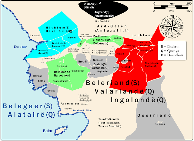
Cette carte a été conçue pour clarifier les positions des Royaumes elfes qui apparaissent dans le Silmarillion. En effet, les cartes "officielles" de Christopher Tolkien, et les cartes de l'atlas bien connu de Karen Wynn Fonstad (publié dans les années 90), toutes monochromes, sont confuses.

Dans la partie nord de la carte, on voit très clairement comment les Elfes  Ñoldor (dont les différents clans sont figurés par 3 couleurs cyan/vert/rouge) entourent et assiègent Morgoth retranché dans sa forteresse d'Angband. On voit aussi comment ceux-ci se partagent le Beleriand avec les elfes Sindar (figurés en gris).

Les toponymes sont donnés en Sindarin par défaut, mais une lettre entre parenthèses indique un nom dans une autre langue, si elle existe (S : Sindarin, Q : Quenya, D : Doriathrin).

Beaucoup de frontières restent incertaines, comme les Falas ou le royaume de Nargothrond.


***

A propos de l'Atlas du Beleriand


Cet Atlas est une série de dix cartes (ou plus!) concernant la géographie, l'histoire et la géopolitique dans le Beleriand, le territoire des évènements du Silmarillion.

Cette carte a été créée pour illustrer un essai dédié à la géopolitique en Beleriand publié sur le site JRRvf. La carte a été améliorée et ensuite publiée sur Deviantart.


***

Détails techniques

Deux polices de caractères ont été utilisées : Franklin Gothic Medium et Cardo de David J. Perry.


***

Bibliographie

  • K.W. Fonstad, The Atlas of Middle-Earth, revised edition, Houghton Mifflin, 1991.


Sunday, March 19, 2017

A clear map of kingdoms appearing in the Silmarillion

A clear map of kingdoms appearing in the Silmarillion


(click on the picture to enlarge it)

Lands of Beleriand (Atlas of Beleriand - Map 1)


This map was designed firstly to clarify the location of kingdoms in Beleriand. On this point of view, I think the two-color maps of K.W. Fonstad and C.Tolkien in the Silmarillion are especially unclear. There is a compromise between the number of informations and the clarity.

The map shows the realms and territories of Beleriand, the land where the events of the Silmarillion took place. Different colors indicate the principal elf clans (cyan/green/red : Ñoldor, grey : Sindar). Toponyms are given in Sindarin by default, but a letter inside brackets indicates a name in another tongue, if it exists (S : Sindarin, Q : Quenya, D : Doriathrin).


***

About the Atlas of Beleriand

This Atlas is a serie of ten maps (and more !) concerning geography, history and geopolitics of Beleriand, which is a territory of  the famous Legendarium of J.R.R. Tolkien, including the Silmarillion.

A plentyful atlas was published previously by Karen W. Fonstad but it is not dedicated specifically to the First Age.

This map was firstly created to illustrate an essay (in french) dedicated to explore the geopolitics in Beleriand published on the website JRRvf. The map was then updated and released on Deviantart.


***

Technical details

In these maps, two free fonts are used : Franklin Gothic Medium and Cardo by David J. Perry.


***

Bibliography

  • K.W. Fonstad, The Atlas of Middle-Earth, revised edition, Houghton Mifflin, 1991.


A new blog on the works of J.R.R. Tolkien

Welcome to this blog,

It is dedicated to the works of Prof. J.R.R. Tolkien.

For my pleasure I drew maps or infographies about the works of Tolkien, and I will release it on Deviantart, and on this blog.

I will start by a serie of ten maps about Beleriand and the events described in the Silmarillion.

The blog will be updated each week, and in 2 languages : french and english, if possible.


Enjoy,
Airyyn.